


Chemin Dassy vers l'arche naturelle

Fdum
User
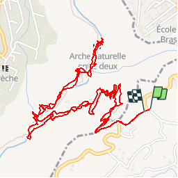

Length
6.2 km

Max alt
554 m

Uphill gradient
483 m
Km-Effort
12.7 km

Min alt
243 m

Downhill gradient
487 m
Boucle
Yes
Creation date :
2017-04-22 00:00:00.0
Updated on :
2017-04-22 00:00:00.0
2h53
Difficulty : Easy

FREE GPS app for hiking
 SityTrail
IGN / Geographical institutes
SityTrail Plus
The world is yours!
About
Trail Walking of 6.2 km to be discovered at Réunion, Unknown, Le Tampon. This trail is proposed by Fdum.
Description
Ballade bien connue des gens du secteur et des sportifs.
Positioning
Country:
France
Region :
Réunion
Department/Province :
Unknown
Municipality :
Le Tampon
Location:
Unknown
Start:(Dec)
Start:(UTM)
343316 ; 7649683 (40K) S.
Comments